there are 4 Types Of Fronts
• A collision of two air masses forms a front—a narrow region between two air masses of different densities.
Severe Weather Notes:
Thunderstorms can produce hail and thunder storms. They form when there is moist air in the lower levels if the atmosphere. Some mechanism must lift the air so that the moisture can condense and release latent heat. The portion of the atmosphere through which the cloud grows must be unstable. Three stages of thunderstorms are cumulous stage, mature stage, and dissipation stage. Supercells are extremely powerful thunderstorms. Lighting is an electrical discharge caused by the friction of falling and rising ice crystals within strong drafts of a cumulonimbus cloud. Downbursts are violent downdrafts. A tornado is a violent, whirling column of air in contact with the ground. Before a tornado reaches the ground it is called a funnel cloud. Fujita tornado intensity scale classifies tornadoes. Saffir- Simpson scale measures intensity for hurricanes.
Air Mass Notes:
Climate is the long term average of variations in weather for a particular area. Thermal energy redistribution is the constant movement of air and water redistributes thermal energy around the world. A source region is the area over which an air mass forms. An air mass is a large volume of air that has the same characteristics such as humidity and temperature, as its source. The origins if maritime tropical air are tropical bodies of water. The southwestern United States and Mexico are the source regions of continental tropical air which is hot and dry, especially in summer. Maritime polar air masses form over the cold waters of the north Atlantic and north pacific. Continental polar air masses form over the interior of Canada and Alaska, and carry frigid air southward in the winter. Earths ice and snow covered surfaces above n latitude in Siberia and the arctic basin are the source regions of arctic air masses. Coriolis Effect results in fluids and objects moving in an apparent curved path rather than a straight line. Jet stream is a narrow band of fast, high altitude, westerly wind.
• A collision of two air masses forms a front—a narrow region between two air masses of different densities.
- Cold Front- When cold, dense air displaces warm air, it forces the warm air, which is less dense, up along a steep slope. This type of collision is called a cold front. Intense precipitation and sometimes thunderstorms.
- Warm Front- Advancing warm air displaces cold air along a warm front. A warm front develops a gradual boundary slope. Widespread light precipitation.
- Stationary Front- When two air masses meet but neither advances, the boundary between them stalls. This stationary front frequently occurs between two modified air masses that have small temperature and pressure gradients between them. Sometimes light winds and precipitation
- Occluded Front- Sometimes, a cold air mass moves so rapidly that it overtakes a warm front and forces the warm air upward. As the warm air is lifted, the advancing cold air mass collides with the cold air mass in front of the warm front. A warm air mass is squeezed upward between two cold air masses. Strong winds and heavy precipitation.
Severe Weather Notes:
Thunderstorms can produce hail and thunder storms. They form when there is moist air in the lower levels if the atmosphere. Some mechanism must lift the air so that the moisture can condense and release latent heat. The portion of the atmosphere through which the cloud grows must be unstable. Three stages of thunderstorms are cumulous stage, mature stage, and dissipation stage. Supercells are extremely powerful thunderstorms. Lighting is an electrical discharge caused by the friction of falling and rising ice crystals within strong drafts of a cumulonimbus cloud. Downbursts are violent downdrafts. A tornado is a violent, whirling column of air in contact with the ground. Before a tornado reaches the ground it is called a funnel cloud. Fujita tornado intensity scale classifies tornadoes. Saffir- Simpson scale measures intensity for hurricanes.
Air Mass Notes:
Climate is the long term average of variations in weather for a particular area. Thermal energy redistribution is the constant movement of air and water redistributes thermal energy around the world. A source region is the area over which an air mass forms. An air mass is a large volume of air that has the same characteristics such as humidity and temperature, as its source. The origins if maritime tropical air are tropical bodies of water. The southwestern United States and Mexico are the source regions of continental tropical air which is hot and dry, especially in summer. Maritime polar air masses form over the cold waters of the north Atlantic and north pacific. Continental polar air masses form over the interior of Canada and Alaska, and carry frigid air southward in the winter. Earths ice and snow covered surfaces above n latitude in Siberia and the arctic basin are the source regions of arctic air masses. Coriolis Effect results in fluids and objects moving in an apparent curved path rather than a straight line. Jet stream is a narrow band of fast, high altitude, westerly wind.
Webquest
a. What is an air mass? An air mass is volume of air defined by its temperature and water vapor content.
b. Explain the difference between a “continental(c) ” air mass, and a “maritime(m)” air mass. Continental is dry and maritime is moist,
c. Explain the difference between a “polar(P)” air mass and a “tropical(T)” air mass. Polar is cold and tropical is hot.
2. They describe an air mass by its Moisture content and Temperature, so each air mass has two letters. Name each air mass and describe it by moisture content and temperature.
cP = Continental polar cT = continental tropical
mP = Maritime polar mT = maritime tropical
3. What causes an air mass to have a low pressure? When the air mass warms up.
4. Look at this picture: Does air move from high pressure to low, or low to high? high to low
5. what are the Global Winds? The global wind pattern is also known as the "general circulation" and the surface winds of each hemisphere are divided into three wind belts
a. Click on the “Pressure Gradient” link. What is the direction of the net force between two pressure systems? From high pressure to low pressure.
b. Click on the “High” link. What is a High Pressure Center and what does it mean? Where the pressure has been measured to be the highest relative to its surroundings
c. In the video, why does the ball not roll straight across the merry-go-round? because of gravity and the pressure
d. How is the Earth similar to the merry-go-round? (look at the figure) it rotates like the merry go round.
e. Wind is an object that is affected by the Coriolis Effect. What happens to winds in the Northern Hemisphere as a results of the Coriolis Effect? Curves winds to the right.
a. Which way does the Coriolis Effect deflect wind in the Northern Hemisphere? It deflects the wind to the right
a. This map shows you isobars and cloud cover. Click on the Help to explain what an isobar is. The wind speed is directly related to the distance between the isobars. The closer they are together, the stronger the pressure gradient, and the stronger the wind
b. Look at the map and find Chicago. Between which two isobars is Chicago? Low pressure isobars
c. Press “Play” on the window, and watch where the clouds travel. Do the clouds tend to be near High pressure centers (H) or Low pressure centers? Low pressure centers
Air ascends (goes up) at Low pressure areas. Why does ascending air allow for clouds to form? The air gets warm which forms clouds
c. Use diagram to determine the direction of wind motion. What is the direction around a High pressure system? It goes counter clockwise
d. What is the direction around a Low pressure system? Clockwise
a. What is a weather front? Two air masses with different temperatures and densities collide but do not mix.
11. Play the Cold front animation and read the information above to answer the questions below.
a. Which air mass is doing the pushing? Cold air pushes
b. What forms when the warm air gets pushed ”up” by the cold air? Rain
c. What kind of clouds form at the frontal boundary? Nimbostratus clouds
d. What weather is associated with this cloud type? Thunder storms
a. Which air mass is doing the pushing? Warm air
b. What forms when the warm air rides “up” over the cold air? Scattered clouds and rain
c. What kind of clouds form at this frontal boundary? Cumulonimbus
d. What kind of clouds are at the very front edge of this boundary? Cumulonimbus
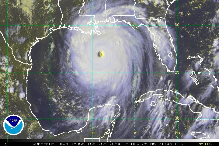
Hurricane Katrina: Even though Katrina had weakened to a Category 3 before landfall along the northern Gulf Coast, its large size and previous extreme intensity sent a huge storm surge into the Mississippi, southeast Louisiana and Alabama coasts. Hurricane Katrina killed nearly 2,000 people and affected some 90,000 square miles of the United States. Hurricane Katrina caused $81 billion in property damages, but it is estimated that the total economic impact in Louisiana and Mississippi may exceed $150 billion, earning the title of costliest hurricane ever in US history. Hurricane Katrina was the largest and 3rd strongest hurricane ever recorded to make landfall in the US.
b. Explain the difference between a “continental(c) ” air mass, and a “maritime(m)” air mass. Continental is dry and maritime is moist,
c. Explain the difference between a “polar(P)” air mass and a “tropical(T)” air mass. Polar is cold and tropical is hot.
2. They describe an air mass by its Moisture content and Temperature, so each air mass has two letters. Name each air mass and describe it by moisture content and temperature.
cP = Continental polar cT = continental tropical
mP = Maritime polar mT = maritime tropical
- Three air masses affect Pennsylvania’s weather the most. Name their air mass symbols and tell me where they come from. cP, cT, mP
3. What causes an air mass to have a low pressure? When the air mass warms up.
4. Look at this picture: Does air move from high pressure to low, or low to high? high to low
5. what are the Global Winds? The global wind pattern is also known as the "general circulation" and the surface winds of each hemisphere are divided into three wind belts
a. Click on the “Pressure Gradient” link. What is the direction of the net force between two pressure systems? From high pressure to low pressure.
b. Click on the “High” link. What is a High Pressure Center and what does it mean? Where the pressure has been measured to be the highest relative to its surroundings
c. In the video, why does the ball not roll straight across the merry-go-round? because of gravity and the pressure
d. How is the Earth similar to the merry-go-round? (look at the figure) it rotates like the merry go round.
e. Wind is an object that is affected by the Coriolis Effect. What happens to winds in the Northern Hemisphere as a results of the Coriolis Effect? Curves winds to the right.
a. Which way does the Coriolis Effect deflect wind in the Northern Hemisphere? It deflects the wind to the right
a. This map shows you isobars and cloud cover. Click on the Help to explain what an isobar is. The wind speed is directly related to the distance between the isobars. The closer they are together, the stronger the pressure gradient, and the stronger the wind
b. Look at the map and find Chicago. Between which two isobars is Chicago? Low pressure isobars
c. Press “Play” on the window, and watch where the clouds travel. Do the clouds tend to be near High pressure centers (H) or Low pressure centers? Low pressure centers
Air ascends (goes up) at Low pressure areas. Why does ascending air allow for clouds to form? The air gets warm which forms clouds
c. Use diagram to determine the direction of wind motion. What is the direction around a High pressure system? It goes counter clockwise
d. What is the direction around a Low pressure system? Clockwise
a. What is a weather front? Two air masses with different temperatures and densities collide but do not mix.
11. Play the Cold front animation and read the information above to answer the questions below.
a. Which air mass is doing the pushing? Cold air pushes
b. What forms when the warm air gets pushed ”up” by the cold air? Rain
c. What kind of clouds form at the frontal boundary? Nimbostratus clouds
d. What weather is associated with this cloud type? Thunder storms
a. Which air mass is doing the pushing? Warm air
b. What forms when the warm air rides “up” over the cold air? Scattered clouds and rain
c. What kind of clouds form at this frontal boundary? Cumulonimbus
d. What kind of clouds are at the very front edge of this boundary? Cumulonimbus
Hurricane Katrina: Even though Katrina had weakened to a Category 3 before landfall along the northern Gulf Coast, its large size and previous extreme intensity sent a huge storm surge into the Mississippi, southeast Louisiana and Alabama coasts. Hurricane Katrina killed nearly 2,000 people and affected some 90,000 square miles of the United States. Hurricane Katrina caused $81 billion in property damages, but it is estimated that the total economic impact in Louisiana and Mississippi may exceed $150 billion, earning the title of costliest hurricane ever in US history. Hurricane Katrina was the largest and 3rd strongest hurricane ever recorded to make landfall in the US.